Gambar:Biot-map.png

Euweuh résolusi nu leuwih luhur.
Biot-map.png (328 × 353 piksel, ukuran koropak: 5 KB, tipeu MIME: image/png)
| Berkas ieu asalna ti Wikimedia Commons. Kaca ngeunaan katerangan berkas ieu di Commons aya disalin di handap. Commons téh hiji gudang berkas bébas nu eusina disumbang ku balaréa. |
Transferred from en.wikipedia to Commons by Maksim.
The original description page was here. All following user names refer to en.wikipedia.
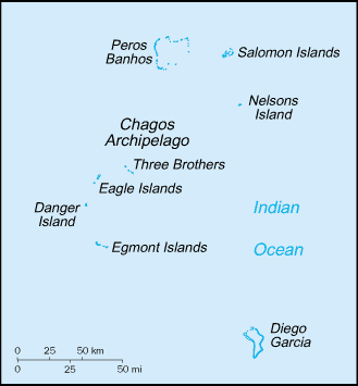
Map of the British Indian Ocean Territory from CIA World Factbook.
Berkas ini berada pada domain publik karena berisi material yang berasal dari The World Factbook yang dipublikasikan oleh CIA
|
 |
| date/time | username | edit summary |
|---|---|---|
| 22:56, 12 November 2004 | en:User:BrokenSegue | ({{PD-USGov-CIA-WF}}) |
| 06:17, 4 June 2004 | en:User:Template namespace initialisation script | |
| 20:15, 23 May 2004 | en:User:Grendelkhan | (clear up PD message) |
| 20:14, 23 May 2004 | en:User:Grendelkhan | (Map of the British Indian Ocean Territory from [http://www.lib.utexas.edu/maps/cia03/british_indian_ocean_sm03.gif CIA World Factbook].<br><br>{{msg:PD}}) |
Log pengunggahan asli
Legend: (cur) = this is the current file, (del) = delete this old version, (rev) = revert to this old version.
Click on date to download the file or see the image uploaded on that date.
- (del) (cur) 22:14, 24 May 2005 . . en:User:Hoshie Hoshie ( en:User_talk:Hoshie Talk) . . 328x353 (4977 bytes) (updated map from 2005 CIA World Factbook, now with a lowercase file name.)
- (del) (rev) 20:14, 23 May 2004 . . en:User:Grendelkhan Grendelkhan ( en:User_talk:Grendelkhan Talk) . . 329x355 (4794 bytes) (Map of the British Indian Ocean Territory from CIA World Factbook.<br><br>{ { msg:PD } })
Jujutan berkas
Klik dina titimangsa pikeun nempo koropak nu aya dina mangsa éta.
| Titimangsa | Miniatur | Ukuran | Pamaké | Kamandang | |
|---|---|---|---|---|---|
| kiwari | 12 Méi 2006 21.11 | | 328 × 353 (5 KB) | Frankie Roberto~commonswiki | Map of the British Indian Ocean Territory from [http://www.lib.utexas.edu/maps/cia03/british_indian_ocean_sm03.gif CIA World Factbook]. {{PD-USGov-CIA-WF}} (copied from http://en.wikipedia.org/wiki/Image:Biot-map.png for use on Wikinews) |
| 26 Maret 2006 11.13 |  | 328 × 353 (5 KB) | Maksim | La bildo estas kopiita de wikipedia:en. La originala priskribo estas: Map of the British Indian Ocean Territory from [http://www.lib.utexas.edu/maps/cia03/british_indian_ocean_sm03.gif CIA World Factbook]. {{PD-USGov-CIA-WF}} {| border="1" ! date/time |
Pamakéan berkas
Ieu berkas dipaké ku kaca di handap:
Pamakéan berkas sajagat
Wiki lianna anu maké ieu berkas:
- Pamakéan di af.wikipedia.org
- Pamakéan di arz.wikipedia.org
- Pamakéan di ast.wikipedia.org
- Pamakéan di bs.wikipedia.org
- Pamakéan di ca.wikipedia.org
- Pamakéan di da.wikipedia.org
- Pamakéan di de.wikipedia.org
- Pamakéan di el.wikipedia.org
- Pamakéan di en.wikipedia.org
- Pamakéan di en.wikinews.org
- Pamakéan di eo.wikipedia.org
- Pamakéan di es.wikipedia.org
- Pamakéan di fa.wikipedia.org
- Pamakéan di fr.wikipedia.org
- Pamakéan di ga.wikipedia.org
- Pamakéan di gl.wikipedia.org
- Pamakéan di hr.wikipedia.org
- Pamakéan di hu.wikipedia.org
- Pamakéan di incubator.wikimedia.org
- Pamakéan di it.wikipedia.org
- Pamakéan di ja.wikipedia.org
- Pamakéan di ko.wikipedia.org
- Pamakéan di lij.wikipedia.org
- Pamakéan di lt.wikipedia.org
- Pamakéan di mzn.wikipedia.org
- Pamakéan di nl.wikipedia.org
- Pamakéan di pl.wikipedia.org
- Pamakéan di pt.wikipedia.org
- Pamakéan di ro.wikipedia.org
Témbongkeun pamakéan global leuwih loba pikeun ieu berkas.