Gambar:India (orthographic projection).svg
Berkas asli(Koropak SVG, nominalna 541 × 541 piksel, ukuranana 280 KB)

Ringkesna

Pedaran
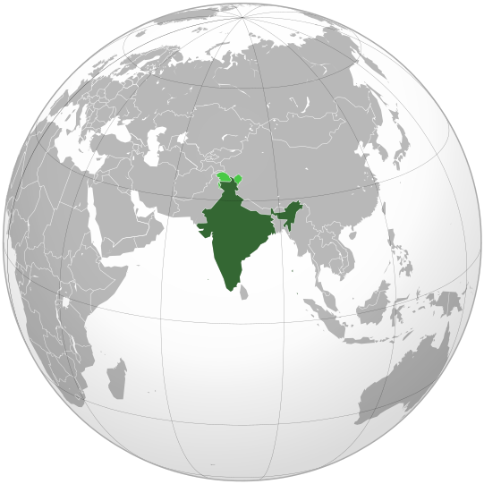
English: India. Area controlled by India in dark green; claimed but not controlled areas in light green.
Titimangsa
Sumber

Own work,

 
Gambar vektor ini dibuat menggunakan Inkscape .

Aquarius.geomar.de

বাংলা  English  español  français  italiano  日本語  македонски  sicilianu  中文(简体)  中文(繁體)  +/−

GNU head Widi dipaparinkeun pikeun nyalin, nyebarkeun jeung/atawa ngarobah ieu dokumén dina payung GNU Free Documentation License, Vérsi 1.2 atawa saluhureunana anu medal ti Free Software Foundation; tanpa Invariant Sections, tanpa Front-Cover Texts, jeung tanpa Back-Cover Texts. Salinan lisénsina diselapkeun dina bab GNU Free Documentation License.
Pangarang Ssolbergj (talk)
Versi lainnya

Karya turunan dari berkas ini:

This is a Grey & green orthographic projection map.
العربية: الرجاء، قراءة الميثاق.
বাংলা: দয়া করে, রীতিনীতিটি পড়ুন
Deutsch: Bitte lies die Konventionen.
English: Please, read the conventions.
Español: Por favor, lea las convenciones.
Filipino: Paki-basa ang mga kumbensyon.
Français : S'il vous plaît, lisez les conventions.
हिन्दी: कृपया सभागमों को पढ़ लें.
Bahasa Indonesia: Silakan, baca konvensi.
Italiano: Si prega di leggere le convenzioni.
ქართული: გთხოვთ, გაეცნოთ კონვენციებს.
Português: Por favor, leia as convenções.
Русский: Пожалуйста, прочитайте соглашения.
Українська: Будь ласка, прочитайте конвенції.
Tiếng Việt: Hãy đọc công văn trước khi đăng.
World maps

Africa

हिन्दी: अफ्रीका
ქართული: აფრიკა.

Eastern Africa

Southern Africa

Central Africa

Northern Africa

Western Africa

Americas

ქართული: ამერიკა.
हिन्दी: अमेरिका

North America

Central America

Caribbean

South America

Asia

ქართული: აზია.
Português: Ásia.
Українська: Азія.

East

Português: Ásia Oriental.
Українська: Східна Азія.

Central

हिन्दी: मध्य एशिया
Português: Ásia Central.
Українська: Центральна Азія.

Southeast

Bahasa Indonesia: Asia tenggara
Português: Sudeste Asiático.

South

(भारतीय उपमहाद्वीप)
Português: Sul da Ásia.
Українська: Південна Азія.

Western

Português: Sudoeste da Ásia.
Українська: Передня Азія.

Europe

हिन्दी: यूरोप
ქართული: ევროპა.
Português: Europa.
Română: Europa.
Русский: Европа.
Українська: Європа.

Countries

Oceania

हिन्दी: ओशिआनिया
ქართული: ოკეანეთი.
Português: Oceania.
Українська: Океанія.

Intercontinental

Português: Intercontinental.
Українська: Міжконтинентальні.

Historical

English: Unions, Organizations, Kingdoms, Empires
Español: Uniones, Organizaciones, Reinos, Imperios
Filipino: Mga Unyon, Organisasyon, Kaharian, Imperyo
Français : Unions, Organisations, Royaumes, Empires
हिन्दी: संघ, संगठन, राज्य, साम्राज्य व ऐतिहासिक देश
ქართული: გაერთიანებები, ორგანიზაციები, სამეფოები, იმპერიები
Português: Estados extintos.
Tagalog: Mga Unyon, Organisasyon, Kaharian, Imperyo
Українська: Союзи, Організації, Королівства, Імперії

Subnationals

हिन्दी: उपराष्ट्रीय इकाईयाँ
Orthographic projections maps created by Ssolbergj
Orthographic projections maps created by Ssolbergj:

Lisénsi

Saya, pemilik hak cipta dari karya ini, dengan ini menerbitkan berkas ini di bawah ketentuan berikut:
GNU head Widi dipaparinkeun pikeun nyalin, nyebarkeun jeung/atawa ngarobah ieu dokumén dina payung GNU Free Documentation License, Vérsi 1.2 atawa saluhureunana anu medal ti Free Software Foundation; tanpa Invariant Sections, tanpa Front-Cover Texts, jeung tanpa Back-Cover Texts. Salinan lisénsina diselapkeun dina bab GNU Free Documentation License.
w:id:Creative Commons
atribusi BabagiSarupa
Ieu berkas dilisénsikeun maké lisénsi Creative Commons Attribution-Share Alike 3.0 Unported.
Anjeun bébas:
  • pikeun babagi – pikeun nyalin, nyebarkeun, sarta nyalabarkeun karyana
  • pikeun nyampurkeun – pikeun ngarobah karyana
Dumasar kana kaayaan di handap:
  • atribusi – Anjeun kudu ngatribusi karya ku cara nu geus ditangtukeun ku nu nyieun atawa nu méré lisénsi (tapi lain ku jalan nu sigana téh maksa pikeun Anjeun maké éta karya).
  • BabagiSarupa – Lamun anjeun ngadumaniskeun, ngarobah, atawa nyieun turunan tina éta bahan, anjeun kudu nyebarkeun kontribusi anjeun maké lisénsi anu sarua jeung nu aslina.
Anjeun bisa milih lisénsi nu cocog.
{{{template}}} Warning! According to Indian law, it is illegal to produce maps that in the view of the Indian government, misrepresent Indian territories by showing areas the Indian government claims ownership of but does not control as not belonging to India or as being contested.

Captions

Add a one-line explanation of what this file represents
india

Items portrayed in this file

menggambarkan Indonesia

status hak cipta Indonesia

berhak cipta Indonesia

sejak Indonesia

Nopémber 2008

tipe media Indonesia

image/svg+xml

Jujutan berkas

Klik dina titimangsa pikeun nempo koropak nu aya dina mangsa éta.

(panganyarna | pangheubeulna) Témbongkeun (leuwih anyar 10 | ) (10 | 20 | 50 | 100 | 250 | 500).
TitimangsaMiniaturUkuranPamakéKamandang
kiwari26 April 2023 07.10'Thumbnail' pikeun vérsi mangsa 26 April 2023 07.10541 × 541 (280 KB)Swtadi143Reverted to version as of 07:34, 16 September 2021 (UTC) siachen glacier is fully controlled by india and not india pakistan jointly, see Siachen conflict for context.
20 Séptémber 2021 10.02'Thumbnail' pikeun vérsi mangsa 20 Séptémber 2021 10.02512 × 512 (155 KB)Ytpks896Reverted to version as of 17:38, 6 September 2021 (UTC) Siachen is a disputed territory not fully controlled by single country it is controlled by both Pakistan and india & some parts by china
16 Séptémber 2021 07.34'Thumbnail' pikeun vérsi mangsa 16 Séptémber 2021 07.34541 × 541 (280 KB)Ksh.andronexusReverted to version as of 16:08, 19 December 2019 (UTC)
6 Séptémber 2021 17.38'Thumbnail' pikeun vérsi mangsa 6 Séptémber 2021 17.38512 × 512 (155 KB)MilenioscuroSiachen is a disputed territory between China, India and Pakistan
19 Désémber 2019 16.08'Thumbnail' pikeun vérsi mangsa 19 Désémber 2019 16.08541 × 541 (280 KB)Goran tek-enAdded border for South Sudan as requested by {{u|Maphobbyist}}
21 Oktober 2017 14.04'Thumbnail' pikeun vérsi mangsa 21 Oktober 2017 14.04541 × 541 (139 KB)Goran tek-enAdded Siachen Glacier as requested by {{u|King Prithviraj II}}
12 Séptémber 2012 21.31'Thumbnail' pikeun vérsi mangsa 12 Séptémber 2012 21.31541 × 541 (167 KB)PalosirkkaScrubbed with http://codedread.com/scour/
15 Nopémber 2009 23.40'Thumbnail' pikeun vérsi mangsa 15 Nopémber 2009 23.40541 × 541 (573 KB)Shibo77+Eritrea, Yemen; -neutral zone
1 Nopémber 2009 13.18'Thumbnail' pikeun vérsi mangsa 1 Nopémber 2009 13.18541 × 541 (496 KB)Pahari SahibMap showing territory governered by India, see map of Pakistan
11 Maret 2009 13.17'Thumbnail' pikeun vérsi mangsa 11 Maret 2009 13.17541 × 541 (572 KB)TryphonReverted to version as of 22:12, 13 February 2009: please use the talk page before reverting this image; there are apparently many people who want the map this way.
(panganyarna | pangheubeulna) Témbongkeun (leuwih anyar 10 | ) (10 | 20 | 50 | 100 | 250 | 500).

Ieu berkas dipaké ku kaca di handap:

Pamakéan berkas sajagat

Wiki lianna anu maké ieu berkas:

Témbongkeun pamakéan global leuwih loba pikeun ieu berkas.

Métadata