Gambar:Khaleej ajam.jpg
Berkas asli (400 × 618 piksel, ukuran koropak: 98 KB, tipeu MIME: image/jpeg)
| Berkas ieu asalna ti Wikimedia Commons. Kaca ngeunaan katerangan berkas ieu di Commons aya disalin di handap. Commons téh hiji gudang berkas bébas nu eusina disumbang ku balaréa. |
Ringkesna
| Pedaran |
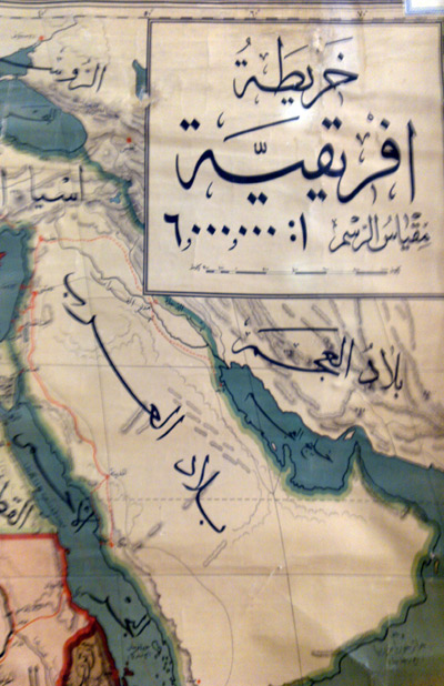
فارسی: نقشهٔ ایران در سال 1908 میلادی othoman map of mamlekat Ajam=persia
English: The map of the Persian Empire in 1908 Egypt library alazhar university |
|||||
| Titimangsa | ||||||
| Sumber | http://www.parssea.persianblog.ir | |||||
| Pangarang | ibrahim. othoman maps | |||||
| Widi (Migunakeun deui ieu berkas) |
|
|||||
| Versi lainnya | it has a explanation in the book [1] | |||||
The map of the Persia in 1908 .
Lisénsi
- Anjeun bébas:
- pikeun babagi – pikeun nyalin, nyebarkeun, sarta nyalabarkeun karyana
- pikeun nyampurkeun – pikeun ngarobah karyana
- Dumasar kana kaayaan di handap:
- atribusi – Anjeun kudu ngatribusi karya ku cara nu geus ditangtukeun ku nu nyieun atawa nu méré lisénsi (tapi lain ku jalan nu sigana téh maksa pikeun Anjeun maké éta karya).
- BabagiSarupa – Lamun anjeun ngadumaniskeun, ngarobah, atawa nyieun turunan tina éta bahan, anjeun kudu nyebarkeun kontribusi anjeun maké lisénsi anu sarua jeung nu aslina.
Ringkesna
| Pedaran |
English: خلیج عــــــــجم |
||
| Titimangsa | |||
| Sumber | Karya sorangan | ||
| Pangarang | Maahmaah | ||
| Widi (Migunakeun deui ieu berkas) |
or [4] [5] I, the copyright holder of this work, hereby publish it under the following license:free for use in public mass medi a i have also published it befor for free |
Lisénsi
- Anjeun bébas:
- pikeun babagi – pikeun nyalin, nyebarkeun, sarta nyalabarkeun karyana
- pikeun nyampurkeun – pikeun ngarobah karyana
- Dumasar kana kaayaan di handap:
- atribusi – Anjeun kudu ngatribusi karya ku cara nu geus ditangtukeun ku nu nyieun atawa nu méré lisénsi (tapi lain ku jalan nu sigana téh maksa pikeun Anjeun maké éta karya).
- BabagiSarupa – Lamun anjeun ngadumaniskeun, ngarobah, atawa nyieun turunan tina éta bahan, anjeun kudu nyebarkeun kontribusi anjeun maké lisénsi anu sarua jeung nu aslina.
Jujutan berkas
Klik dina titimangsa pikeun nempo koropak nu aya dina mangsa éta.
| Titimangsa | Miniatur | Ukuran | Pamaké | Kamandang | |
|---|---|---|---|---|---|
| kiwari | 29 Nopémber 2011 10.26 | | 400 × 618 (98 KB) | Maahmaah |
Pamakéan berkas
Ieu berkas dipaké ku kaca di handap:
Pamakéan berkas sajagat
Wiki lianna anu maké ieu berkas:
- Pamakéan di ar.wikipedia.org
- Pamakéan di arz.wikipedia.org
- Pamakéan di en.wikipedia.org
- Pamakéan di fa.wikipedia.org
- Pamakéan di fa.wikibooks.org
- Pamakéan di fr.wikipedia.org
- Pamakéan di hi.wikipedia.org
- Pamakéan di ja.wikipedia.org
- Pamakéan di my.wikipedia.org
- Pamakéan di pnb.wikipedia.org
- Pamakéan di ro.wikipedia.org
- Pamakéan di ru.wikipedia.org
- Pamakéan di simple.wikipedia.org
- Pamakéan di sr.wikipedia.org
- Pamakéan di tg.wikipedia.org
- Pamakéan di tr.wikipedia.org
- Pamakéan di tt.wikipedia.org
- Pamakéan di uk.wikipedia.org