Gambar:Lake MacKay Australia.jpg

Berkas asli (4.101 × 3.288 piksel, ukuran koropak: 9,87 MB, tipeu MIME: image/jpeg)
| Berkas ieu asalna ti Wikimedia Commons. Kaca ngeunaan katerangan berkas ieu di Commons aya disalin di handap. Commons téh hiji gudang berkas bébas nu eusina disumbang ku balaréa. |
Ringkesna
| Pedaran |
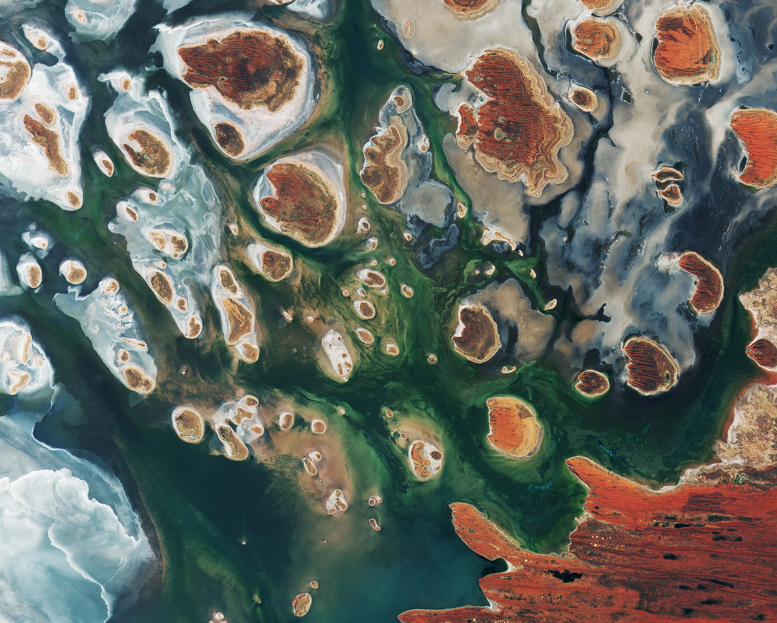
English: Lake Mackay, Australia, by Copernicus Sentinel-2B satellite.
Brown hills speckle the eastern part of Australia’s Lake Mackay in this satellite image. Located on the border of the states of Western Australia and Northern Territory, the salt lake only sees water after seasonal rainfall – if at all. It is classified as an ephemeral lake, meaning it exists only after precipitation. This is not the same as a seasonal lake, which sees water for longer periods. About half of Australia's rivers drain inland and often end in ephemeral salt lakes. The greens and blues in this image show desert vegetation or algae, soil moisture and minerals – mainly salt. On some of the brown ‘islands’ and on the shore in the lower right, we can see the east–west sand ridges forming lines in the landscape. The lake lies at the edge of the Great Sandy Desert, which covers nearly 285,000 sq km. Roads are scarce in the area, and often frequented by four-wheel drive adventurers. Roads include the Canning Stock Route about 300 km to the west of the image, or Tanami Track connecting Australia’s Stuart Highway to the Great Northern Highway around 300 km to the east.Español: Lago Mackay, Australia, fotografiado por el satélite Copernicus Sentinel-2B.
Colinas marrones se esparzan a través del lado oriental del lago Mackay, Australia. Ubicado en la frontera del estado de Australia Occidental y el Territorio del Norte, el lago recibe agua solamente después de las lluvias estacionales, si acaso. Se clasifica como un lago efímero, lo cual indica que existe únicamente como resultado de la precipitación. En cambio, un lago estacional recibe agua por periodos más largos. Casi la mitad de los ríos de Australia drenan en el interior y desembocan frecuentemente en lagos de salado efímeros. Las partes de colores verde y azul en esta imagen indican la presencia de vegetación del desierto, alga, la humedad de tierra y minerales, principalmente sal. En algunas de las islitas marrones y a la orilla en el lado inferior derecho, se pueden ver unas crestas de arena que corren al lado oriental al occidental formando líneas rectas en el paisaje. Se encuentra el lago al filo del Gran Desierto Arenoso, lo cual abarca casi 285.000 kilómetros cuadrados. Caminos son escasos en el región y son frecuentados por aventureros que manejan todoterrenos. Algunos caminos son la Ruta Canning Stock aproximadamente 300 km al oeste fuera del imagen, y la Pista Tanami aproximadamente 300 km al este, la cual conecta la autopista nacional Stuart a la Gran Autopista del Norte. |
| Titimangsa | |
| Sumber | http://www.esa.int/spaceinimages/Images/2017/04/Lake_MacKay_Australia |
| Pangarang | ESA / Copernicus Sentinel |
| Versi lainnya |
|

| Lokasi kamera | | Lihat gambar ini dan gambar di sekitarnya di: OpenStreetMap |
|---|
|
Lisénsi
This media was created by the European Space Agency (ESA).
Where expressly so stated, images or videos are covered by the Creative Commons Attribution-ShareAlike 3.0 IGO (CC BY-SA 3.0 IGO) licence, ESA being an Intergovernmental Organisation (IGO), as defined by the CC BY-SA 3.0 IGO licence. The user is allowed under the terms and conditions of the CC BY-SA 3.0 IGO license to Reproduce, Distribute and Publicly Perform the ESA images and videos released under CC BY-SA 3.0 IGO licence and the Adaptations thereof, without further explicit permission being necessary, for as long as the user complies with the conditions and restrictions set forth in the CC BY-SA 3.0 IGO licence, these including that:
See the ESA Creative Commons copyright notice for complete information, and this article for additional details.
|
 | |
Berkas ini dilisensikan di bawah lisensi Creative Commons Atribusi-Berbagi Serupa 3.0 IGO. Atribusi: ESA, CC BY-SA IGO 3.0
| ||
Berkas ini sebelumnya diunggah ke http://www.esa.int/spaceinimages/Images/2017/04/Lake_MacKay_Australia dan ditinjau pada tanggal 6 Mei 2017 oleh pengguna peninjau yaitu Daphne Lantier yang mengonfirmasi bahwa pada tanggal tersebut berkas ini betul memiliki lisensi sesuai yang dinyatakan.
|

|
This image contains data from a satellite in the Copernicus Programme, such as Sentinel-1, Sentinel-2 or Sentinel-3. Attribution is required when using this image.
Atribusi: Contains modified Copernicus Sentinel data 2017
The use of Copernicus Sentinel Data is regulated under EU law (Commission Delegated Regulation (EU) No 1159/2013 and Regulation (EU) No 377/2014). Relevant excerpts:
Free access shall be given to GMES dedicated data [...] made available through GMES dissemination platforms [...].
Access to GMES dedicated data [...] shall be given for the purpose of the following use in so far as it is lawful:
GMES dedicated data [...] may be used worldwide without limitations in time.
GMES dedicated data and GMES service information are provided to users without any express or implied warranty, including as regards quality and suitability for any purpose. |
Jujutan berkas
Klik dina titimangsa pikeun nempo koropak nu aya dina mangsa éta.
| Titimangsa | Miniatur | Ukuran | Pamaké | Kamandang | |
|---|---|---|---|---|---|
| kiwari | 5 Méi 2017 11.00 | | 4.101 × 3.288 (9,87 MB) | Yann | HR from TIFF, 98% compression |
| 5 Méi 2017 10.51 |  | 1.920 × 1.539 (3,01 MB) | Yann | Transferred from http://www.esa.int/var/esa/storage/images/esa_multimedia/images/2017/04/lake_mackay_australia/16906510-1-eng-GB/Lake_MacKay_Australia.jpg |
Pamakéan berkas
Ieu berkas dipaké ku 2 kaca di handap:
Pamakéan berkas sajagat
Wiki lianna anu maké ieu berkas:
- Pamakéan di bn.wikibooks.org
- Pamakéan di ca.wikipedia.org
- Pamakéan di en.wikipedia.org
- Pamakéan di fa.wikibooks.org
- Pamakéan di fr.wikipedia.org
- Pamakéan di gl.wikipedia.org
- Pamakéan di he.wikipedia.org
- Pamakéan di hy.wikipedia.org
- Pamakéan di hy.wikibooks.org
- Pamakéan di pt.wikipedia.org
- Pamakéan di ru.wikipedia.org
- Pamakéan di sv.wikipedia.org
- Pamakéan di uk.wikipedia.org
- Pamakéan di vi.wikipedia.org