Gambar:MerguiArchipelagoMap.png
Ukuran ieu pramidang: 322 × 598 pixel. Resolusi lianna: 129 × 240 pixel | 258 × 480 pixel | 973 × 1.808 pixel.
Berkas asli (973 × 1.808 piksel, ukuran koropak: 61 KB, tipeu MIME: image/png)
| Berkas ieu asalna ti Wikimedia Commons. Kaca ngeunaan katerangan berkas ieu di Commons aya disalin di handap. Commons téh hiji gudang berkas bébas nu eusina disumbang ku balaréa. |
Ringkesna
| Pedaran |
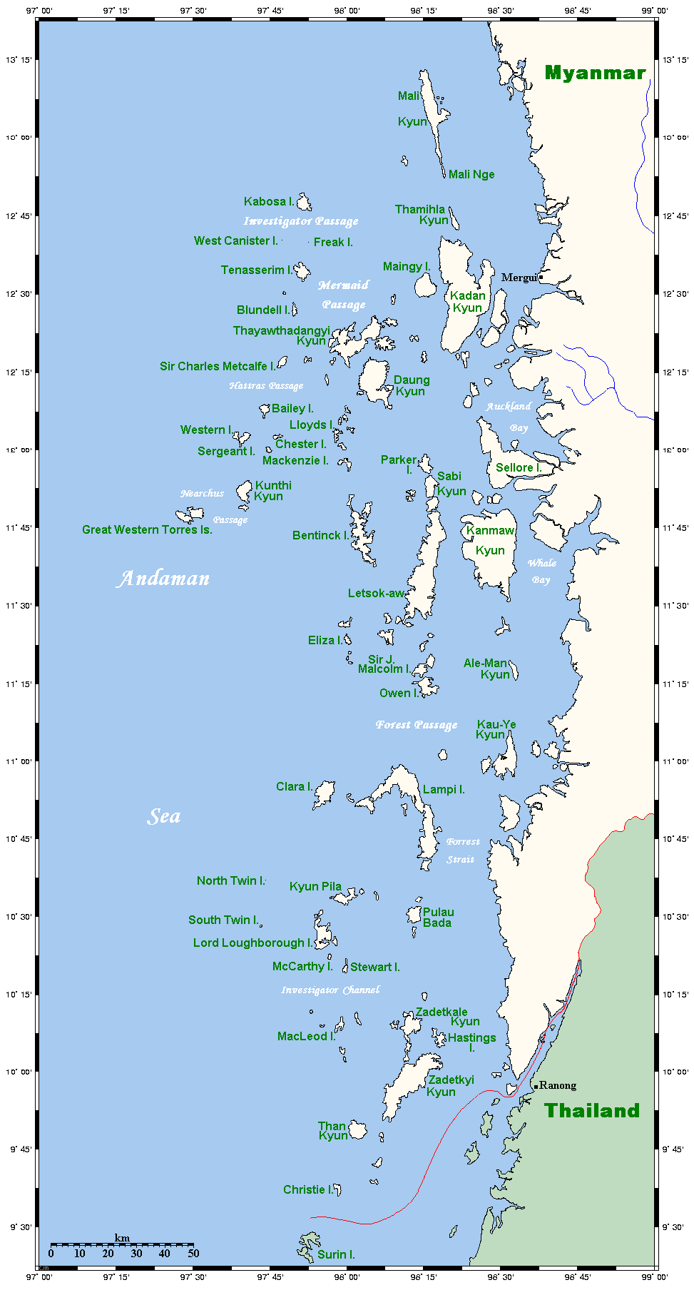
Map of the Mergui Archipelago in Myanmar. This map's source is here, with the uploader's modifications, and the GMT homepage says that the tools are released under the GNU General Public License. There is a somewhat bigger map of this area, showing places farther north and south. This is not on Wikipedia, but leave a message at my talk page if you would like such a thing, and likewise if you know any further information that ought to go on this map. |
| Titimangsa | 14 Méi 2006 (original upload date) |
| Sumber | Transferred from en.wikipedia to Commons. |
| Pangarang | Kelisi di Wikipédia bahasa Inggris |
Lisénsi
Kelisi from en.wikipedia.org, pemilik hak cipta dari karya ini, dengan ini menerbitkan berkas ini di bawah ketentuan berikut:
| Ieu berkas dilisénsikeun maké lisénsi Creative Commons Attribution-Share Alike 3.0 Unported. Subject to disclaimers. | ||
| Atribusi: Kelisi from en.wikipedia.org | ||
| ||
| Label lisensi ini ditambahkan pada berkas sebagai bagian dari pemutakhiran lisensi GFDL. |

|
Widi dipaparinkeun pikeun nyalin, nyebarkeun jeung/atawa ngarobah ieu dokumén dina payung GNU Free Documentation License, Vérsi 1.2 atawa saluhureunana anu medal ti Free Software Foundation; tanpa Invariant Sections, tanpa Front-Cover Texts, jeung tanpa Back-Cover Texts. Salinan lisénsina diselapkeun dina bab GNU Free Documentation License. Subject to disclaimers. |
Log pengunggahan asli
The original description page was here. All following user names refer to en.wikipedia.
- 2006-05-14 20:32 Kelisi 973×1808×8 (62506 bytes) Map of the Mergui Archipelago in Myanmar. This map's source is [http://www.aquarius.geomar.de/omc/make_map.html here], with the uploader's modifications, and the [http://gmt.soest.hawaii.edu/ GMT homepage] says that the tools are released under the GNU Ge
Jujutan berkas
Klik dina titimangsa pikeun nempo koropak nu aya dina mangsa éta.
| Titimangsa | Miniatur | Ukuran | Pamaké | Kamandang | |
|---|---|---|---|---|---|
| kiwari | 1 Méi 2007 23.20 | | 973 × 1.808 (61 KB) | Ppntori | {{Information |Description=Map of the Mergui Archipelago in Myanmar. This map's source is [http://www.aquarius.geomar.de/omc/make_map.html here], with the uploader's modifications, and the [http://gmt.soest.hawaii.edu/ GMT homepage] says that the tools ar |
Pamakéan berkas
Ieu berkas dipaké ku kaca di handap:
Pamakéan berkas sajagat
Wiki lianna anu maké ieu berkas:
- Pamakéan di ar.wikipedia.org
- Pamakéan di arz.wikipedia.org
- Pamakéan di ban.wikipedia.org
- Pamakéan di bcl.wikipedia.org
- Pamakéan di bg.wikipedia.org
- Pamakéan di bh.wikipedia.org
- Pamakéan di bn.wikipedia.org
- Pamakéan di bs.wikipedia.org
- Pamakéan di ca.wikipedia.org
- Pamakéan di ckb.wikipedia.org
- Pamakéan di cy.wikipedia.org
- Pamakéan di de.wikipedia.org
- Pamakéan di en.wikipedia.org
- Pamakéan di es.wikipedia.org
- Pamakéan di fa.wikipedia.org
- Pamakéan di fi.wikipedia.org
- Pamakéan di fr.wikipedia.org
- Pamakéan di fy.wikipedia.org
- Pamakéan di ga.wikipedia.org
- Pamakéan di hi.wikipedia.org
- Pamakéan di hu.wikipedia.org
- Pamakéan di ia.wikipedia.org
- Pamakéan di id.wikipedia.org
- Pamakéan di ilo.wikipedia.org
- Pamakéan di incubator.wikimedia.org
- Pamakéan di io.wikipedia.org
- Pamakéan di it.wikipedia.org
- Pamakéan di ja.wikipedia.org
- Pamakéan di jv.wikipedia.org
- Pamakéan di kk.wikipedia.org
- Pamakéan di km.wikipedia.org
- Pamakéan di kn.wikipedia.org
- Pamakéan di ko.wikipedia.org
- Pamakéan di lt.wikipedia.org
- Pamakéan di min.wikipedia.org
- Pamakéan di mk.wikipedia.org
- Pamakéan di ml.wikipedia.org
Témbongkeun pamakéan global leuwih loba pikeun ieu berkas.