Gambar:Morocco (orthographic projection).svg

Ukuran ieu pramidang PNG ti ieu berkas SVG: 550 × 550 pixel Resolusi lianna: 240 × 240 pixel | 480 × 480 pixel | 768 × 768 pixel | 1.024 × 1.024 pixel | 2.048 × 2.048 pixel.
Berkas asli (Koropak SVG, nominalna 550 × 550 piksel, ukuranana 307 KB)
| Berkas ieu asalna ti Wikimedia Commons. Kaca ngeunaan katerangan berkas ieu di Commons aya disalin di handap. Commons téh hiji gudang berkas bébas nu eusina disumbang ku balaréa. |
Sahara marocain
Ringkesna

| Pedaran |
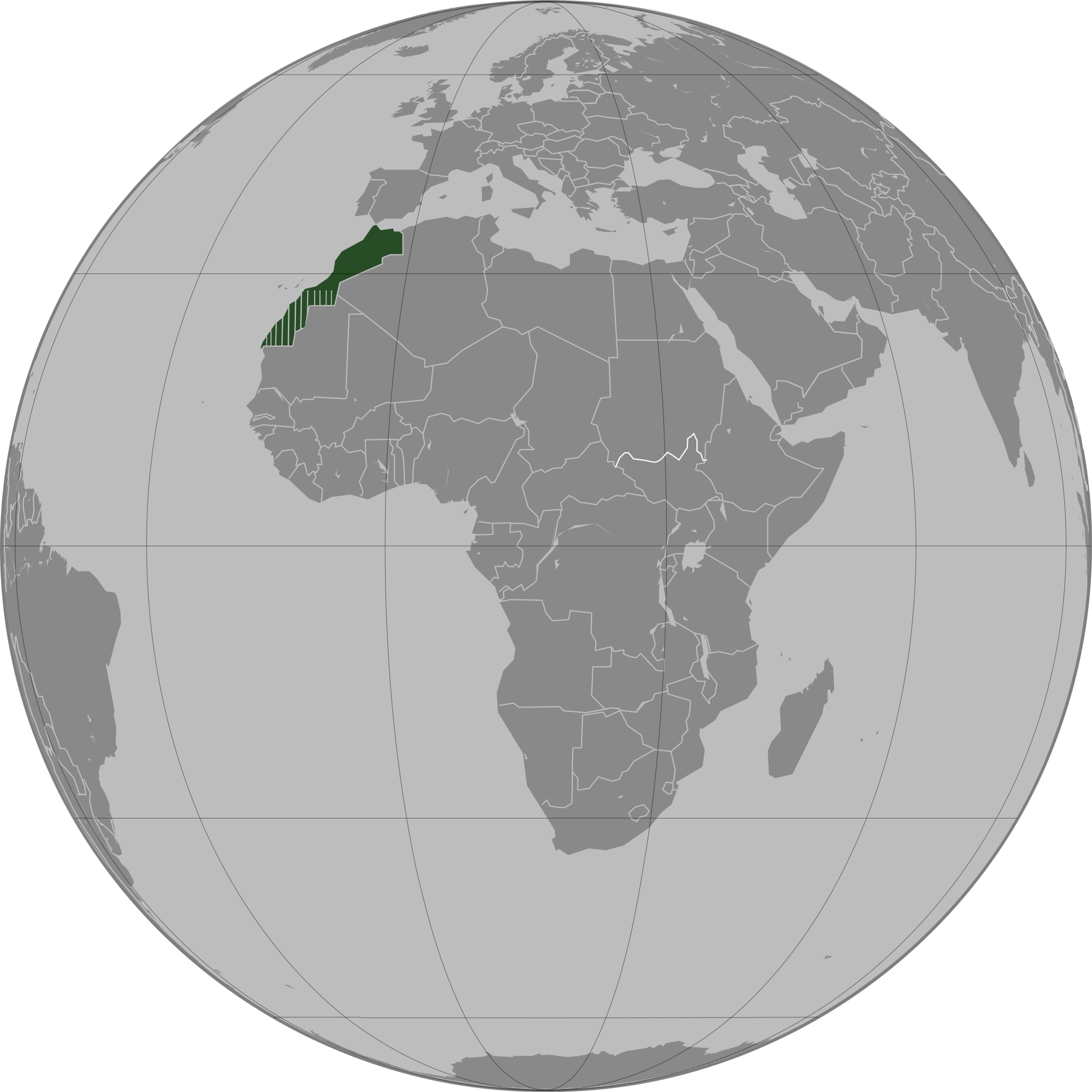
العربية: تحديد المغرب مع إقليمه المتنازع عليه الصحراء المغربية بشكل مخطط، الأمم المتحدة تعترف بصحراء المغرب.
Español: Localización de Marruecos y del territorio ocupado del Sahara Occidental. Ni las Naciones Unidas ni nungún país del mundo reconoce a Marruecos la soberanía sobre dicho territorio, que a ojos de la Comunidad Internacional sigue siendo considerado un Territorio No Autónomo pendiente de descolonización como así lo corrobora el informe S/2002/161.
Français : Localisation du Maroc et de son territoire contesté Sahara occidental, en pointillés. Les Nations Unies reconnaissent au Maroc la souveraineté administrative sur ce territoire.
Deutsch: Lokalisierung Marokkos und seines strittigen Territoriums Westsahara, gestrichelt dargestellt. Die Vereinten Nationen gestehen Marokko Verwaltungshoheit über das Territorium zu.
English: Locator of Morocco and the disputed territory Western Sahara shown as striped. United Nations recognize Morocco as an administrative power of the territory.
Português: Localização de Marrocos e do seu território contestado Saara Ocidental, tracejado. As Nações Unidas concedem a Marrocos a soberania administrativa sobre esse território. |
||||
| Titimangsa | |||||
| Sumber |
Karya sorangan
|
||||
| Pangarang | Flad | ||||
| Versi lainnya |
|
.svg)
.svg)
.svg)
.svg)
_highlighted.svg)
.svg)
.svg)
والمغرب في صحرائه وصحراء في مغربها
Lisénsi

|
Widi dipaparinkeun pikeun nyalin, nyebarkeun jeung/atawa ngarobah ieu dokumén dina payung GNU Free Documentation License, Vérsi 1.2 atawa saluhureunana anu medal ti Free Software Foundation; tanpa Invariant Sections, tanpa Front-Cover Texts, jeung tanpa Back-Cover Texts. Salinan lisénsina diselapkeun dina bab GNU Free Documentation License. |
| Ieu berkas dilisénsikeun maké lisénsi Creative Commons Attribution-Share Alike 3.0 Unported. | ||
| ||
| Label lisensi ini ditambahkan pada berkas sebagai bagian dari pemutakhiran lisensi GFDL. |
Jujutan berkas
Klik dina titimangsa pikeun nempo koropak nu aya dina mangsa éta.
.svg&dir=prev)
.svg&offset=20110503163341)
.svg&offset=&limit=20)
.svg&offset=&limit=50)
.svg&offset=&limit=100)
.svg&offset=&limit=250)
.svg&offset=&limit=500)
| Titimangsa | Miniatur | Ukuran | Pamaké | Kamandang | |
|---|---|---|---|---|---|
| kiwari | 13 Agustus 2011 04.40 | | 550 × 550 (307 KB) | Banhtrung1 | Added the South Sudan. |
| 9 Méi 2011 19.30 |  | 550 × 550 (292 KB) | Omar-Toons | please read the description + consensus that this is the right version to be shared under this name | |
| 9 Méi 2011 19.28 |  | 550 × 550 (293 KB) | Eddo | User talk:Omar-Toons | |
| 9 Méi 2011 16.22 |  | 550 × 550 (292 KB) | Omar-Toons | Reverted to version as of 13:04, 8 May 2011 please read the description | |
| 9 Méi 2011 06.25 |  | 550 × 550 (293 KB) | Eddo | Reverted to version as of 07:11, 8 May 2011 | |
| 8 Méi 2011 13.04 |  | 550 × 550 (292 KB) | Rekaf | Reverted to version as of 00:02, 6 July 2010 -- the original file is already striped, you can upload a new version with light-green | |
| 8 Méi 2011 07.11 |  | 550 × 550 (293 KB) | Eddo | West Sahara is not part of Morocco | |
| 6 Méi 2011 08.15 |  | 550 × 550 (292 KB) | Omar-Toons | Reverted to version as of 16:33, 3 May 2011 Another version (WS excluded) exists. Reverting non-consensual change | |
| 3 Méi 2011 18.01 |  | 550 × 550 (293 KB) | Eddo | Redrawing the border between Morocco and West Sahara, please don't erase it | |
| 3 Méi 2011 16.33 |  | 550 × 550 (292 KB) | Flad | Reverted to version as of 00:02, 6 July 2010 |
Pamakéan berkas
Euweuh kaca anu maké ieu berkas.
Pamakéan berkas sajagat
Wiki lianna anu maké ieu berkas:
- Pamakéan di ar.wikipedia.org
- Pamakéan di ca.wikipedia.org
- Pamakéan di da.wikipedia.org
- Pamakéan di en.wikipedia.org
- Pamakéan di en.wikinews.org
- Pamakéan di es.wikipedia.org
- Pamakéan di fr.wikipedia.org
- Pamakéan di fr.wikinews.org
- Pamakéan di incubator.wikimedia.org
- Pamakéan di nap.wikipedia.org
- Pamakéan di tr.wikipedia.org
.svg)