Gambar:Physical Map of Europe.jpg
Euweuh résolusi nu leuwih luhur.
Physical_Map_of_Europe.jpg (719 × 476 piksel, ukuran koropak: 185 KB, tipeu MIME: image/jpeg)
| Berkas ieu asalna ti Wikimedia Commons. Kaca ngeunaan katerangan berkas ieu di Commons aya disalin di handap. Commons téh hiji gudang berkas bébas nu eusina disumbang ku balaréa. |
- Extended map (enlarged labels): Image:Europe_terrain_CIA_map_extended.jpg.
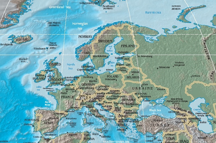
Ringkesna
| Pedaran | Terrain map of Europe, as cropping from the CIA's Physical Map of the World. |
| Titimangsa | Map dated April 2008 |
| Sumber |
Cropped section from the CIA's Physical Map of the World, formerly available at: but moved to webpage (March 2009): Those webpage URLs require secure-post ("https"), for access, because those pages are encrypted. The larger image this one was cropped from may or may not still be available. |
| Pangarang | work of U.S. CIA |
| Versi lainnya |
Same map in expanded form (more labels):
|
Lisénsi
Berkas ini berada pada domain publik karena berisi material yang berasal dari The World Factbook yang dipublikasikan oleh CIA
|
 |
Jujutan berkas
Klik dina titimangsa pikeun nempo koropak nu aya dina mangsa éta.
| Titimangsa | Miniatur | Ukuran | Pamaké | Kamandang | |
|---|---|---|---|---|---|
| kiwari | 19 Oktober 2005 11.56 | | 719 × 476 (185 KB) | Grillo | Physical map of Europe. Cropped from http://cia.gov/cia/publications/factbook/reference_maps/pdf/physical_world.pdf and converted to JPG. From en:Image:Physical Map of Europe.jpg {{PD-USGov-CIA-WF}} |
Pamakéan berkas
Ieu berkas dipaké ku kaca di handap:
Pamakéan berkas sajagat
Wiki lianna anu maké ieu berkas:
- Pamakéan di as.wikipedia.org
- Pamakéan di bat-smg.wikipedia.org
- Pamakéan di bg.wiktionary.org
- Pamakéan di cy.wikipedia.org
- Pamakéan di da.wikipedia.org
- Sveriges geografi
- Norges geografi
- Danmarks geografi
- Frankrigs geografi
- Irlands geografi
- Liechtensteins geografi
- Tysklands geografi
- Østrigs geografi
- Europas geografi
- Slovakiets geografi
- Monacos geografi
- Tjekkiets geografi
- Sloveniens geografi
- Storbritanniens geografi
- Tyrkiets geografi
- Schweiz' geografi
- Skabelon:Europas geografi
- Hollands geografi
- Ukraines geografi
- Grækenlands geografi
- Pamakéan di de.wikipedia.org
- Pamakéan di el.wikipedia.org
- Pamakéan di en.wikipedia.org
- Pamakéan di es.wikipedia.org
- Pamakéan di es.wikibooks.org
- Pamakéan di fr.wikipedia.org
- Pamakéan di id.wikipedia.org
- Pamakéan di it.wikipedia.org
- Pamakéan di ko.wikiquote.org
- Pamakéan di ky.wikipedia.org
- Pamakéan di lrc.wikipedia.org
- Pamakéan di map-bms.wikipedia.org
- Pamakéan di mk.wikipedia.org
Témbongkeun pamakéan global leuwih loba pikeun ieu berkas.