Gambar:Map of Pompeii in Roman Campania.png
Euweuh résolusi nu leuwih luhur.
Map_of_Pompeii_in_Roman_Campania.png (400 × 260 piksel, ukuran koropak: 60 KB, tipeu MIME: image/png)
| Berkas ieu asalna ti Wikimedia Commons. Kaca ngeunaan katerangan berkas ieu di Commons aya disalin di handap. Commons téh hiji gudang berkas bébas nu eusina disumbang ku balaréa. |
Ringkesna
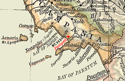
Map of Campania during the Roman period, highlighting Pompeii.
Extracted and adapted from The Historical Atlas by William R. Shepherd, 1911.
Original image is at http://www.lib.utexas.edu/maps/historical/shepherd_1911/shepherd-c-030-031.jpg
Lisénsi
This media file is in the public domain in the United States. This applies to U.S. works where the copyright has expired, often because its first publication occurred prior to January 1, 1929, and if not then due to lack of notice or renewal. See this page for further explanation.
|
 | |
 |
This image might not be in the public domain outside of the United States; this especially applies in the countries and areas that do not apply the rule of the shorter term for US works, such as Canada, Mainland China (not Hong Kong or Macao), Germany, Mexico, and Switzerland. The creator and year of publication are essential information and must be provided. See Wikipedia:Public domain and Wikipedia:Copyrights for more details.
|
Jujutan berkas
Klik dina titimangsa pikeun nempo koropak nu aya dina mangsa éta.
| Titimangsa | Miniatur | Ukuran | Pamaké | Kamandang | |
|---|---|---|---|---|---|
| kiwari | 16 Nopémber 2005 19.50 | | 400 × 260 (60 KB) | Marcus Cyron | == Summary == Map of Campania during the Roman period, highlighting Pompeii. Extracted and adapted from ''The Historical Atlas'' by William R. Shepherd, 1911. Original image is at http://www.lib.utexas.edu/maps/historical/shephe |
Pamakéan berkas
Ieu berkas dipaké ku kaca di handap:
Pamakéan berkas sajagat
Wiki lianna anu maké ieu berkas:
- Pamakéan di bg.wikipedia.org
- Pamakéan di ca.wikipedia.org
- Pamakéan di da.wikipedia.org
- Pamakéan di en.wikipedia.org
- Pamakéan di es.wikipedia.org
- Pamakéan di et.wikipedia.org
- Pamakéan di hu.wikipedia.org
- Pamakéan di it.wikipedia.org