Gambar:Sint Maarten-CIA WFB Map.png
Euweuh résolusi nu leuwih luhur.
Sint_Maarten-CIA_WFB_Map.png (330 × 353 piksel, ukuran koropak: 14 KB, tipeu MIME: image/png)
| Berkas ieu asalna ti Wikimedia Commons. Kaca ngeunaan katerangan berkas ieu di Commons aya disalin di handap. Commons téh hiji gudang berkas bébas nu eusina disumbang ku balaréa. |
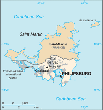
| Pedaran | Map of Sint Maarten from the 2010-10-22 revision of the World Factbook |
| Titimangsa | |
| Sumber | World Factbook website |
| Pangarang | Directorate of Intelligence, CIA |
Berkas ini berada pada domain publik karena berisi material yang berasal dari The World Factbook yang dipublikasikan oleh CIA
|
 |
Jujutan berkas
Klik dina titimangsa pikeun nempo koropak nu aya dina mangsa éta.
| Titimangsa | Miniatur | Ukuran | Pamaké | Kamandang | |
|---|---|---|---|---|---|
| kiwari | 23 Oktober 2010 11.32 | | 330 × 353 (14 KB) | Hoshie | {{Information |Description= Map of {{w|Sint Maarten}} from the 2010-10-22 revision of the World Factbook |Source= [https://www.cia.gov/library/publications/the-world-factbook/maps/maptemplate_sk.html World Factbook website] |Date= 2010-10-22 |Author= Dire |
Pamakéan berkas
Ieu berkas dipaké ku kaca di handap:
Pamakéan berkas sajagat
Wiki lianna anu maké ieu berkas:
- Pamakéan di af.wikipedia.org
- Pamakéan di bn.wikipedia.org
- Pamakéan di ceb.wikipedia.org
- Pamakéan di el.wikipedia.org
- Pamakéan di en.wikipedia.org
- Pamakéan di fa.wikipedia.org
- Pamakéan di fr.wikipedia.org
- Pamakéan di gcr.wikipedia.org
- Pamakéan di gom.wikipedia.org
- Pamakéan di hi.wikipedia.org
- Pamakéan di hu.wikipedia.org
- Pamakéan di ia.wikipedia.org
- Pamakéan di id.wikipedia.org
- Pamakéan di incubator.wikimedia.org
- Pamakéan di it.wikipedia.org
- Pamakéan di ja.wikipedia.org
- Pamakéan di lad.wikipedia.org
- Pamakéan di lb.wikipedia.org
- Pamakéan di mk.wikipedia.org
- Pamakéan di ml.wikipedia.org
- Pamakéan di nl.wikipedia.org
- Pamakéan di pa.wikipedia.org
- Pamakéan di pl.wikipedia.org
- Pamakéan di ru.wikipedia.org
- Pamakéan di sc.wikipedia.org
- Pamakéan di shn.wikipedia.org
- Pamakéan di simple.wikipedia.org
- Pamakéan di ta.wikipedia.org
- Pamakéan di to.wikipedia.org
- Pamakéan di tr.wikipedia.org
- Pamakéan di tt.wikipedia.org
- Pamakéan di uk.wikipedia.org
- Pamakéan di ur.wikipedia.org
- Pamakéan di vec.wikipedia.org
- Pamakéan di www.wikidata.org
- Pamakéan di zh-yue.wikipedia.org
- Pamakéan di zh.wikipedia.org