Gambar:Mt Vesuvius 79 AD eruption-la.svg

Ukuran ieu pramidang PNG ti ieu berkas SVG: 800 × 480 pixel Resolusi lianna: 320 × 192 pixel | 1.024 × 614 pixel | 1.280 × 768 pixel | 2.560 × 1.536 pixel.
Berkas asli (Koropak SVG, nominalna 800 × 480 piksel, ukuranana 86 KB)
| Berkas ieu asalna ti Wikimedia Commons. Kaca ngeunaan katerangan berkas ieu di Commons aya disalin di handap. Commons téh hiji gudang berkas bébas nu eusina disumbang ku balaréa. |
Ringkesna
| Pedaran |
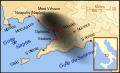
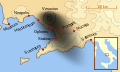
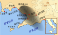
English: A map showing the cities and towns (with their Latin names which were affected by the eruption of Mount Vesuvius in 79 AD ; the general shape of the ash and cinder fall —see w:en:pyroclast— is shown by the dark area to the southeast of Mt Vesuvius.
This map shows modern day coast lines and uses the Mercator projection (although that is not important on a map of this scale). North is, as usual, at the top of the map. Español: El mapa muestra las ciudades y los poblados (con sus nombres en latín) que fueron afectados por la erupción del Vesubio del año 79 d.C. ; las cenizas y los residuos de la erupción volcánica —consultar Piroclasto (tefra)— cayeron al sureste del Monte Vesubio, donde está indicado por la zona oscurecida. |
| Titimangsa | |
| Sumber | Karya sorangan |
| Pangarang | MapMaster |
References
This map is intended to show the general distribution of (airborne) ash punice, and other particles. I built the map from descriptions of the event as well as these maps:
- Luongo, Giuseppe; Perrotta, Annamaria; Scarpati, Claudio;De Carolis, Ernesto;Patricelli, Giovanni;Ciarallo, Annamaria (2003) "Impact of the AD 79 explosive eruption on Pompeii" in Journal of Volcanology and Geothermal Research v126 pp. 169-200.
- This map.
- Image:Pompeya, el Vesuvio y su alcance.jpg
Other versions
[]
-
 English
 -
 français
 -
 Latina
 -
 Nederlands
 -
 português
 -
 македонски
 -
 русский
 -
 中文
中文 -
 עברית
עברית


|
Berkas SVG ini memiliki teks yang bisa diterjemahkan ke bahasa lain, dengan menggunakan editor SVG, editor teks atau Alat terjemahan SVG. Untuk informasi lebih lanjut lihat: About translating SVG files. |
Lisénsi
Saya, pemilik hak cipta dari karya ini, dengan ini menerbitkan berkas ini di bawah ketentuan berikut:

|
Widi dipaparinkeun pikeun nyalin, nyebarkeun jeung/atawa ngarobah ieu dokumén dina payung GNU Free Documentation License, Vérsi 1.2 atawa saluhureunana anu medal ti Free Software Foundation; tanpa Invariant Sections, tanpa Front-Cover Texts, jeung tanpa Back-Cover Texts. Salinan lisénsina diselapkeun dina bab GNU Free Documentation License. |
Berkas ini dilisensikan dengan lisensi Creative Commons Atribusi-BerbagiSerupa 3.0 Tanpa Adaptasi, 2.5 Generik, 2.0 Generik, dan 1.0 Generik.
- Anjeun bébas:
- pikeun babagi – pikeun nyalin, nyebarkeun, sarta nyalabarkeun karyana
- pikeun nyampurkeun – pikeun ngarobah karyana
- Dumasar kana kaayaan di handap:
- atribusi – Anjeun kudu ngatribusi karya ku cara nu geus ditangtukeun ku nu nyieun atawa nu méré lisénsi (tapi lain ku jalan nu sigana téh maksa pikeun Anjeun maké éta karya).
- BabagiSarupa – Lamun anjeun ngadumaniskeun, ngarobah, atawa nyieun turunan tina éta bahan, anjeun kudu nyebarkeun kontribusi anjeun maké lisénsi anu sarua jeung nu aslina.
Anjeun bisa milih lisénsi nu cocog.
Jujutan berkas
Klik dina titimangsa pikeun nempo koropak nu aya dina mangsa éta.
| Titimangsa | Miniatur | Ukuran | Pamaké | Kamandang | |
|---|---|---|---|---|---|
| kiwari | 6 April 2018 08.00 | | 800 × 480 (86 KB) | -donald- | K changed to km |
| 28 Nopémber 2014 22.04 |  | 800 × 480 (88 KB) | Ras67 | frame removed | |
| 19 Oktober 2007 00.17 |  | 659 × 396 (113 KB) | MapMaster | slight modification | |
| 15 Oktober 2007 22.35 |  | 659 × 396 (113 KB) | MapMaster | slight image fix-up | |
| 15 Oktober 2007 17.52 |  | 652 × 396 (113 KB) | MapMaster | == Summary == {{Information |Description=A map showing the cities and towns affected by the eruption of Mount Vesuvius in 79 AD. The general shape of the ash and cinder fall (see w:en:pyroclast) is shown by the dark area to the southeast of Mt Vesuvi |
Pamakéan berkas
Ieu berkas dipaké ku kaca di handap:
Pamakéan berkas sajagat
Wiki lianna anu maké ieu berkas:
- Pamakéan di af.wikipedia.org
- Pamakéan di bg.wikipedia.org
- Pamakéan di br.wikipedia.org
- Pamakéan di ca.wikipedia.org
- Pamakéan di cs.wikipedia.org
- Pamakéan di da.wikipedia.org
- Pamakéan di de.wikipedia.org
- Pamakéan di de.wikivoyage.org
- Pamakéan di en.wikipedia.org
- Pamakéan di es.wikipedia.org
- Pamakéan di et.wikipedia.org
- Pamakéan di fi.wikipedia.org
- Pamakéan di fr.wikipedia.org
- Pamakéan di fur.wikipedia.org
Témbongkeun pamakéan global leuwih loba pikeun ieu berkas.