Modul:Location map/data/Indonésia Jawa
Usage
| name | Jawa | |||
|---|---|---|---|---|
| border coordinates | ||||
| -4.5 | ||||
| 104.8 | ←↕→ | 116.5 | ||
| -10.7 | ||||
| map center | 7°36′S 110°39′E / 7.6°S 110.65°E | |||
| image | Indonesia Java location map.svg
| |||

| ||||
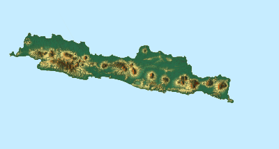
| image1 | Java Relief Map.svg
| |||

| ||||
Modul:Location map/data/Indonésia Jawa is a location map definition used to overlay markers and labels on an equirectangular projection map of Jawa. The markers are placed by latitude and longitude coordinates on the default map or a similar map image.
Usage
These definitions are used by the following templates when invoked with parameter "Indonésia Jawa":
- {{Location map | Indonésia Jawa | ...}}
- {{Location map many | Indonésia Jawa | ...}}
- {{Location map+ | Indonésia Jawa | ...}}
- {{Location map~ | Indonésia Jawa | ...}}
Map definition
name = Jawa- Name used in the default map caption
image = Indonesia Java location map.svg- The default map image, without "Image:" or "File:"
image1 = Java Relief Map.svg- An alternative map image, usually a relief map, can be displayed via the relief or AlternativeMap parameters
top = -4.5- Latitude at top edge of map, in decimal degrees
bottom = -10.7- Latitude at bottom edge of map, in decimal degrees
left = 104.8- Longitude at left edge of map, in decimal degrees
right = 116.5- Longitude at right edge of map, in decimal degrees
Alternative map
The map defined as image1 (Java Relief Map.svg) can be displayed by using the relief or AlternativeMap parameters in {{Location map}}, {{Location map many}} and {{Location map+}}. The use of these two parameters is shown in the examples below. Additional examples can be found at:
- Template:Location map#Relief parameter
- Template:Location map#AlternativeMap parameter
- Template:Location map+/relief
- Template:Location map+/AlternativeMap
Precision
Longitude: from West to East this map definition covers 11.7 degrees.
- At an image width of 200 pixels, that is 0.0585 degrees per pixel.
- At an image width of 1000 pixels, that is 0.0117 degrees per pixel.
Latitude: from North to South this map definition covers 6.2 degrees.
- At an image height of 200 pixels, that is 0.031 degrees per pixel.
- At an image height of 1000 pixels, that is 0.0062 degrees per pixel.
See also
- Location map templates
- Template:Location map, to display one mark and label using latitude and longitude
- Template:Location map many, to display up to nine marks and labels
- Template:Location map+, to display an unlimited number of marks and labels
- Infobox templates incorporating (passing values to) the Location map template
- Template:Infobox airport — alternative map support: relief (via pushpin_relief) and AlternativeMap (via pushpin_image)
- Template:Infobox ancient site — alternative map support: relief
- Template:Infobox artwork
- Template:Infobox building — alternative map support: relief
- Template:Infobox casino
- Template:Infobox castrum — alternative map support: relief (via map_relief)
- Template:Infobox cave (via Infobox map) — alternative map support: relief
- Template:Infobox cemetery
- Template:Infobox civil conflict
- Template:Infobox climbing route (via Infobox map) — alternative map support: relief
- Template:Infobox church — alternative map support: relief
- Template:Infobox concentration camp
- Template:Infobox dam — alternative map support: relief
- Template:Infobox dava
- Template:Infobox forest (via Infobox map) — alternative map support: relief
- Template:Infobox glacier (via Infobox map) — alternative map support: relief (displays relief image unless map_relief=0)
- Template:Infobox golf facility — alternative map support: relief
- Template:Infobox historic site — alternative map support: relief (via map_relief)
- Template:Infobox hospital — alternative map support: relief
- Template:Infobox hut — alternative map support: relief
- Template:Infobox lighthouse — alternative map support: relief
- Template:Infobox map (used by other infoboxes) — alternative map support: relief
- Template:Infobox military conflict — alternative map support: relief (via map_relief)
- Template:Infobox military installation — alternative map support: relief (via map_relief)
- Template:Infobox monastery
- Template:Infobox mountain (via Infobox map) — alternative map support: relief (displays relief image unless map_relief=0)
- Template:Infobox mountain pass (via Infobox map) — alternative map support: relief (displays relief image unless map_relief=0)
- Template:Infobox mountain range (via Infobox map) — alternative map support: relief (displays relief image unless map_relief=0)
- Template:Infobox museum — alternative map support: relief (via map_relief)
- Template:Infobox oil field — alternative map support: relief
- Template:Infobox oil refinery — alternative map support: relief
- Template:Infobox operational plan
- Template:Infobox park (via Infobox map) — alternative map support: relief
- Template:Infobox power station — alternative map support: relief
- Template:Infobox protected area (via Infobox map) — alternative map support: relief
- Template:Infobox reactor
- Template:Infobox religious building — alternative map support: relief
- Template:Infobox restaurant
- Template:Infobox settlement — alternative map support: relief (via pushpin_relief) and AlternativeMap (via pushpin_image)
- Template:Infobox spring (via Infobox map) — alternative map support: relief
- Template:Infobox temple
- Template:Infobox terrestrial impact site
- Template:Infobox valley (via Infobox map) — alternative map support: relief
- Template:Infobox waterfall (via Infobox map) — alternative map support: relief
- Template:Infobox World Heritage Site — alternative map support: relief