Gambar:Lion distribution.png
Ukuran ieu pramidang: 687 × 600 pixel. Resolusi lianna: 275 × 240 pixel | 550 × 480 pixel | 880 × 768 pixel.
Berkas asli (880 × 768 piksel, ukuran koropak: 51 KB, tipeu MIME: image/png)
| Berkas ieu asalna ti Wikimedia Commons. Kaca ngeunaan katerangan berkas ieu di Commons aya disalin di handap. Commons téh hiji gudang berkas bébas nu eusina disumbang ku balaréa. |
Ringkesna
| Pedaran |
Euskara: Lehoien banaketa: Berdez gaur egun, gorriz historikoki.
Suomi: Leijonan levinneisyys vanhalla ajalla.
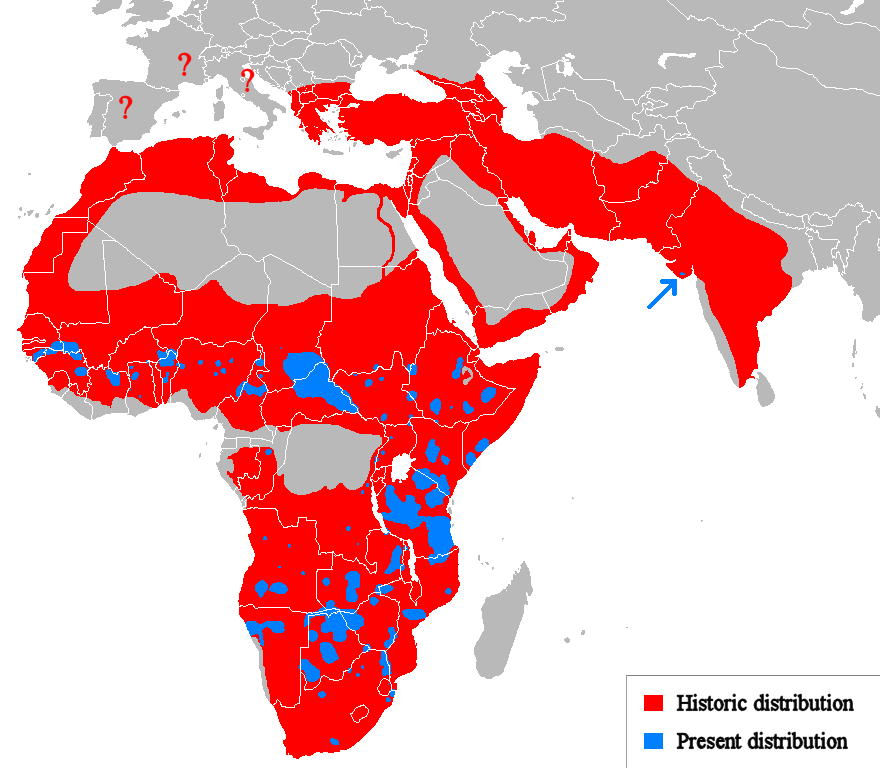
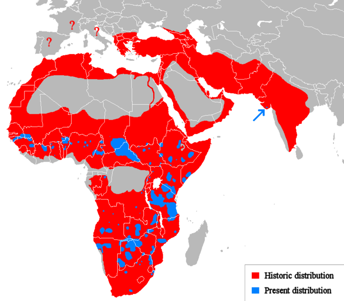
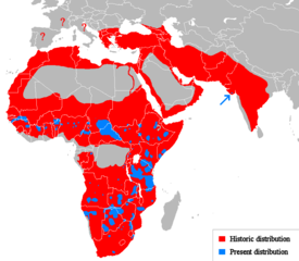
English: Geographical distribution of lions. Red (and blue) shows areas historically inhabited, blue shows areas currently inhabited.
Italiano: Areale storico (in rosso) ed attuale (in blu).
Русский: Ареал льва |
| Titimangsa | (UTC) |
| Sumber |
Own work using:
|
| Pangarang | Tommyknocker (talk) |
| Versi lainnya | Derivative works of this file: Lion distribution-ar.png |
Lisénsi
| Karya ini dilepaskan ke domain umum oleh pemiliknya, Tommyknocker di Wikipédia bahasa Inggris. Lisensi ini berlaku di seluruh dunia. Di sejumlah negara, tindakan ini tidak memungkinkan secara sah; bila seperti itu: Tommyknocker memberikan siapa pun hak untuk menggunakan karya ini untuk tujuan apa pun, tanpa persyaratan apa pun, kecuali yang ditetapkan oleh hukum. |
Log pengunggahan asli
Transferred from en.wikipedia to Commons by Egmontaz using CommonsHelper.
The original description page was here. All following user names refer to en.wikipedia.
- 2009-08-26 11:21 Tommyknocker 882×770× (42518 bytes) '
- 2009-08-24 21:02 Tommyknocker 882×770× (42434 bytes) {{Information |Description = |Source = I (~~~) created this work entirely by myself. |Date = ~~~~~ |Author = ~~~ |other_versions = }}
Jujutan berkas
Klik dina titimangsa pikeun nempo koropak nu aya dina mangsa éta.
| Titimangsa | Miniatur | Ukuran | Pamaké | Kamandang | |
|---|---|---|---|---|---|
| kiwari | 22 Maret 2018 11.51 | | 880 × 768 (51 KB) | Maphobbyist | Check |
| 22 Maret 2018 11.23 |  | 880 × 768 (51 KB) | Maphobbyist | South Sudan border | |
| 15 Méi 2012 01.07 |  | 880 × 768 (33 KB) | Ras67 | cropped, optimized | |
| 19 April 2010 14.06 |  | 882 × 770 (59 KB) | MPF | Change red/green to red/blue to avoid problems for viewers with red-green colourblindness | |
| 11 Januari 2010 20.00 |  | 882 × 770 (44 KB) | Tommyknocker | Distribution in Southern Europe during historical times controversial, therefore now represented with question marks. | |
| 2 Nopémber 2009 17.01 |  | 882 × 770 (42 KB) | File Upload Bot (Magnus Manske) | {{BotMoveToCommons|en.wikipedia|year={{subst:CURRENTYEAR}}|month={{subst:CURRENTMONTHNAME}}|day={{subst:CURRENTDAY}}}} {{Information |Description={{en|''no original description''}} |Source=Transferred from [http://en.wikipedia.org en.wikipedia]; transfer |
Pamakéan berkas
Ieu berkas dipaké ku kaca di handap:
Pamakéan berkas sajagat
Wiki lianna anu maké ieu berkas:
- Pamakéan di ab.wikipedia.org
- Pamakéan di af.wikipedia.org
- Pamakéan di alt.wikipedia.org
- Pamakéan di am.wikipedia.org
- Pamakéan di ary.wikipedia.org
- Pamakéan di arz.wikipedia.org
- Pamakéan di ast.wikipedia.org
- Pamakéan di as.wikipedia.org
- Pamakéan di azb.wikipedia.org
- Pamakéan di ban.wikipedia.org
- Pamakéan di ba.wikipedia.org
- Pamakéan di bcl.wikipedia.org
- Pamakéan di be.wikipedia.org
- Pamakéan di bg.wikipedia.org
- Pamakéan di bh.wikipedia.org
- Pamakéan di bn.wikipedia.org
- Pamakéan di bs.wikipedia.org
- Pamakéan di ca.wikipedia.org
- Pamakéan di ca.wikiquote.org
- Pamakéan di ceb.wikipedia.org
- Pamakéan di ce.wikipedia.org
- Pamakéan di ckb.wikipedia.org
- Pamakéan di cs.wikipedia.org
- Pamakéan di de.wikipedia.org
- Pamakéan di de.wikibooks.org
- Pamakéan di diq.wikipedia.org
- Pamakéan di el.wikipedia.org
- Pamakéan di en.wikipedia.org
- Pamakéan di eo.wikipedia.org
- Pamakéan di eo.wiktionary.org
- Pamakéan di es.wikipedia.org
- Pamakéan di es.wikibooks.org
- Pamakéan di et.wikipedia.org
- Pamakéan di eu.wikipedia.org
Témbongkeun pamakéan global leuwih loba pikeun ieu berkas.