Gambar:Pedro Reinel 1504.jpg
Berkas asli (3.418 × 2.312 piksel, ukuran koropak: 6 MB, tipeu MIME: image/jpeg)
| Berkas ieu asalna ti Wikimedia Commons. Kaca ngeunaan katerangan berkas ieu di Commons aya disalin di handap. Commons téh hiji gudang berkas bébas nu eusina disumbang ku balaréa. |
|
This image was selected as picture of the day on Wikimedia Commons for 3 January 2009. It was captioned as follows: Other languages:
Afrikaans: Seekaart van die Portugese kartograaf Pedro Reinel, om en by 1504 Čeština: Námořní mapa portugalského kartografa Pedro Reinela, cca 1504 Dansk: Portugisisk søkort, af Pedro Reinel, ca. 1504 Eesti: Portugali merekaart. Autor Pedro Reinel, u. 1504. Français : Carte marine du cartographe portugais Pedro Reinel, vers 1504. Magyar: Pedro Reinel portugál tengerész 1504 körül készült hajózási térképe (Bayerische Staatsbibliothek, München) Português: Carta atlântica de Pedro Reinel (c. 1504) Română: Hartă nautică a Oceanului Atlantic, de Pedro Reinel, circa 1504 Slovenčina: Námorná mapa portugalského kartografa Pedra Reinela, cca 1504 Suomi: Portugalilaisen Pedro Reinelin tekemä merikartta vuodelta 1504. Svenska: Portugisiskt sjökort, av Pedro Reinel, ca. 1504 Türkçe: Pedro Reinel'e ait Portekizce denizcilik haritası, yak. 1504 Македонски: Португалска морепловна карта од Педро Реинел (~1504) 中文: 葡萄牙制图师佩德罗·赖内尔绘制的航海图,约绘于1504年 中文(繁體): 葡萄牙製圖師佩德羅·賴內爾繪製的航海圖,約繪於1504年。 فارسی : نقشه دریانوردی پرتقالی پدرو رینیل در سال ۱۵۰۴ |
Ringkesna
| Deskripsi |
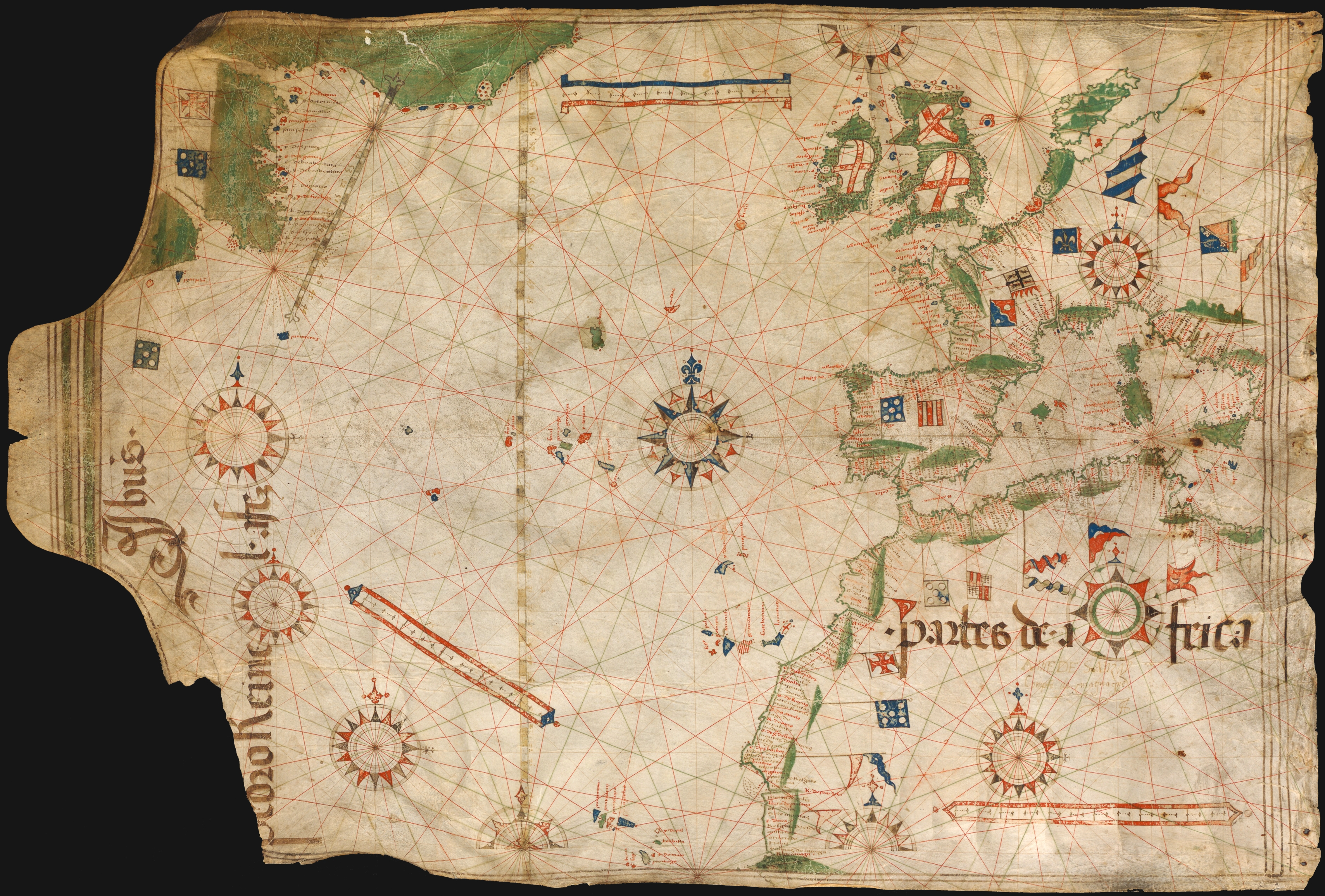
Português: Carta náutica de Pedro Reinel representando o Atlântico Norte (c. 1504).
English: Portuguese nautical chart by Pedro Reinel, c. 1504.
Français : Carte de 1504-1505 du navigateur portugais Pedro Reinel montrant à gauche la côte est de Terre-Neuve, avec la première rose des vents pointant le nord. |
|||||||||
| Titimangsa | circa 1504 | |||||||||
| Sumber | Bayerische Staatsbibliothek, Munchen | |||||||||
| Pencipta |
Pedro Reinel |
|||||||||
| Widi (Migunakeun deui ieu berkas) |
|
|||||||||
| Geotemporal data | ||||||||||
| Bounding box |
|
|||||||||
| Georeferencing | ||||||||||
| Versi lainnya |
Derivative works of this file: Compass rose from Pedro Reinel (1504) chart.jpg  |
|||||||||
_chart.jpg)
Jujutan berkas
Klik dina titimangsa pikeun nempo koropak nu aya dina mangsa éta.
| Titimangsa | Miniatur | Ukuran | Pamaké | Kamandang | |
|---|---|---|---|---|---|
| kiwari | 11 Oktober 2008 20.40 | | 3.418 × 2.312 (6 MB) | Alvesgaspar | {{Information |Description=Portuguese nautical chart by Pedro Reinel, c. 1504 |Source=Bayerische Staatsbibliothek, Munchen |Date=c. 1504 |Author=Pedro Reinel |Permission=below |other_versions= }} Category:Photos by Alvesgaspar Category:Old charts |
Pamakéan berkas
Ieu berkas dipaké ku 2 kaca di handap:
Pamakéan berkas sajagat
Wiki lianna anu maké ieu berkas:
- Pamakéan di bn.wikipedia.org
- Pamakéan di crh.wikipedia.org
- Pamakéan di cs.wikipedia.org
- Pamakéan di cv.wikipedia.org
- Pamakéan di de.wikipedia.org
- Pamakéan di en.wikipedia.org
- User:Alvesgaspar
- Pedro Reinel
- History of cartography
- Portal:Maps/Selected picture
- Wikipedia:Featured pictures/Diagrams, drawings, and maps/Maps
- Wikipedia:Featured pictures thumbs/13
- Wikipedia:Featured picture candidates/October-2008
- Wikipedia:Featured picture candidates/Image:Pedro Reinel 1504.jpg
- Wikipedia:Wikipedia Signpost/2008-11-08/Features and admins
- Wikipedia:Wikipedia Signpost/2008-11-08/SPV
- Portal:Maps/Selected picture/46
- Wikipedia:Picture of the day/June 2009
- Template:POTD/2009-06-18
- User talk:Alvesgaspar/archive1
- User:Peter Mercator/Map gallery
- Portuguese Renaissance
- Wikipedia:GLAM/NHMandSM/booklet
- Portal:Maps
- Wikipedia:Wikipedia Signpost/Single/2008-11-08
- Pamakéan di en.wiktionary.org
- Pamakéan di eo.wikipedia.org
- Vikipedio:Bildo de la tago/2009 01
- Vikipedio:Bildo de la tago/2009 02
- Pedro Reinel
- Vikipedio:Bildo de la tago/2011 02
- Vikipedio:Bildo de la tago/2011 01
- Vikipedio:Bildo de la tago/2010 02
- Vikipedio:Bildo de la tago/2010 01
- Vikipedio:Bildo de la tago/2012 02
- Vikipedio:Bildo de la tago/2012 01
- Vikipedio:Bildo de la tago2/indekso/3
- Ŝablono:Bildo de la Tago2/128
- Pamakéan di es.wikipedia.org
- Pamakéan di es.wiktionary.org
- Pamakéan di fi.wikipedia.org
- Pamakéan di fr.wikipedia.org
- Pamakéan di fr.wiktionary.org
- Pamakéan di gl.wikipedia.org
Témbongkeun pamakéan global leuwih loba pikeun ieu berkas.