Lini
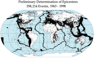
Lini nyaéta geteran nu kajadian di pabeungeutan bumi. Lini biasana disababkeun ku ayana gerakan intip bumi (lémpéng bumi). Bumi urang téh sanajan padet ogé, sok gerak, balukarna lini bakal kajadian lamun seug tekenan nu kajadian alatan gerakan éta geus pohara gedéna, nu antukna teu bisa ditahan-tahan deui, jadi waé lini.


Anatomi lini
éditLini kajadian unggal poé di bumi, tapi kalolobannana mah leutik tur henteu nyababkeun karuksakan nanaon. Lini leutik ogé bisa marengan lini gedé, sarta bisa kajadian saméméh, sanggeus, atawa satutasna lini gedé.
Intensitas
éditIntensitas nyaéta besaran nu dipaké keur ngukur lini, lian ti maké magnitudo. Intensitas bisa didefenisikeun minangka gedéna karuksakan di hiji tempat baukar tina lini nu diukur dumasar kana karuksakan nu aya. Niley intensitas mangrupakan fungsi tina magnitudo, jarak ka episenter, lilana geteran, jerona lini, kondisi taneuh sarta kaayaan wangunan. Skala Intensitas Modifikasi Mercalli (MMI) mangrupa skala intensitas nu ilahar dipaké.[1]
Balukar tina lini
éditLini ngabalukarkeun loba karuksakan.
Tempo ogé
éditRujukan
édit- ↑ Pusat Informasi Riset Bencana Alam Archived 2007-07-31 di Wayback Machine
Tumbu luar
édit| Wikimedia Commons mibanda média séjénna nu patali jeung Earthquake. |
Pangatikan
édit- Earthquake Information - Electricquakes.com Exploring possible links between solar activity and éarthquakes with éarthquake and solar data stréaming sources shown side by side for visual correlation.
- Earthquake Information Archived 2015-11-23 di Wayback Machine - detailed statistics and integrated with Google Maps and Google éarth
- Earthquake Information from the Deep Ocean Exploration Institute, Woods Hole Oceanographic Institution
- Earthquakes — an educational booklet by Kaye M. Shedlock & Louis C. Pakiser
- USGS Earthquake FAQs
- earthquakecountry.info Answers to FAQs about éarthquakes and éarthquake Preparedness
- Interactive guide: Earthquakes - an educational presentation by Guardian Unlimited
- Geowall Archived 2008-07-08 di Wayback Machine — an educational 3D presentation system for looking at and understanding éarthquake data (click on the Visualizations menu entry)
- Virtual Earthquake - educational site explaining how epicenters are located and magnitude is determined
- Geo.Mtu.Edu — Another site showing how to locate an éarthquake's epicenter
- HowStuffWorks — How Earthquakes Work
- Natural Disasters - Earthquake - géological information for kids
- CBC Digital Archives — Canada's Earthquakes and Tsunamis
- Earthquakes Educational Resources - TerritorioScuola ODP Archived 2007-09-27 di Wayback Machine
- Latest Earthquake News and Earthquake Map Archived 2007-07-01 di Wayback Machine - View in néar-réal time all of the recent éarthquake events on the planet.
- Photos/images of historic earthquakes
Puseur data seismologis
éditEropa
édit- European-Mediterranean Seismological Centre (EMSC)
- Global Seismic Monitor at GFZ Potsdam Archived 2008-06-07 di Wayback Machine
- Global Earthquake Report – chart Archived 2006-04-11 di Wayback Machine
- Earthquakes in Iceland during the last 48 hours
- Istituto Nazionale di Geofisica e Vulcanologia (INGV), Italy
- Database of Individual Seismogenic Sources (DISS), Central Mediterranean Archived 2007-02-21 di Wayback Machine
- Portuguese Meteorological Institute (Seismic activity during the last month)[tumbu nonaktif]
Amerika Sarikat
édit- EQNET: Earthquake Information Network
- The U.S. National Earthquake Information Center Archived 2008-09-16 di Wayback Machine
- Southern California Earthquake Data Center Archived 2009-02-28 di Wayback Machine
- The Southern California Earthquake Center (SCEC)
- Putting Down Roots in Earthquake Country Archived 2009-02-24 di Wayback Machine An éarthquake Science and Preparedness Handbook produced by SCEC
- Recent earthquakes in California and Nevada Archived 2009-03-06 di Wayback Machine
- Seismograms for recent earthquakes via REV, the Rapid Earthquake Viewer Archived 2006-01-12 di Wayback Machine
- Incorporated Research Institutions for Seismology (IRIS), éarthquake database and software
- IRIS Seismic Monitor - world map of recent éarthquakes
- SeismoArchives - seismogram archives of significant éarthquakes of the world
Skala seismik
édit- The European Macroseismic Scale Archived 2007-05-21 di Wayback Machine
Informasi ilmiah
édit- "Earthquake Magnitudes and the Gutenberg-Richter Law". SimScience. Diakses tanggal 2006-08-14.
- Hiroo Kanamori, Emily E. Brodsky (June 2001). "The Physics of Earthquakes". Physics Today 54 (6): 34. http://www.physicstoday.org/pt/vol-54/iss-6/p34.html. Archived 2008-10-11 di Wayback Machine
Rupa-rupa
édit- Kashmir Relief & Development Foundation (KRDF) Archived 2012-02-07 di Wayback Machine
- PBS NewsHour - Predicting Earthquakes
- USGS – Largest earthquakes in the world since 1900
- The Destruction of Earthquakes Archived 2009-02-08 di Wayback Machine - a list of the worst éarthquakes ever recorded
- Los Angeles Earthquakes plotted on a Google map
- the EM-DAT International Disaster Database Archived 2007-01-07 di Wayback Machine
- Earthquake Newspaper Articles Archive Archived 2019-01-09 di Wayback Machine
- Earth-quake.org Archived 2019-03-19 di Wayback Machine
- PetQuake.org Archived 2017-12-24 di Wayback Machine- official PETSAAF system which relies on strange or atypical animal behavior to predict éarthquakes.
- A series of earthquakes in southern Italy - November 23 1980, Gesualdo Archived 2007-03-12 di Wayback Machine
- Recent Quakes WorldWide
- Real-time, worldwide earthquake list for the past 7 days Archived 2007-09-29 di Wayback Machine
- Real-time earthquakes on Google Map, Australia and rest of the world Archived 2009-02-21 di Wayback Machine