Gambar:Majapahit Empire.svg

Ukuran ieu pramidang PNG ti ieu berkas SVG: 512 × 297 pixel Resolusi lianna: 320 × 186 pixel | 640 × 371 pixel | 1.024 × 594 pixel | 1.280 × 743 pixel | 2.560 × 1.485 pixel.
Berkas asli (Koropak SVG, nominalna 512 × 297 piksel, ukuranana 524 KB)
| Berkas ieu asalna ti Wikimedia Commons. Kaca ngeunaan katerangan berkas ieu di Commons aya disalin di handap. Commons téh hiji gudang berkas bébas nu eusina disumbang ku balaréa. |
Ringkesna
| Pedaran |
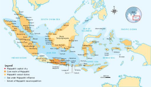
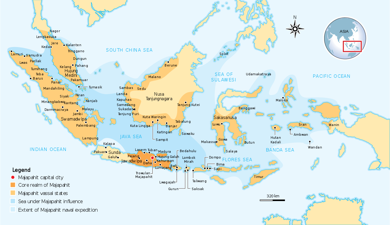
English: The Nusantara Archipelago during the height of Majapahit Empire in XIV century.
The red dot is Trowulan; Majapahit capital city. The dark orange area is core realm of Majapahit on eastern part of Java. The light orange area is vassal states of Majapahit mentioned in Nagarakretagama. The pale yellow is outer realm or independent states from Majapahit. The dark cyan is the sea area under influence or effective control of Majapahit. The light cyan is the extent of Majapahit naval expedition. |
||
| Titimangsa | |||
| Sumber | Own work by uploader, see #References for references used creating the map. | ||
| Pangarang | Gunawan Kartapranata | ||
| Widi (Migunakeun deui ieu berkas) |
Saya, pemilik hak cipta dari karya ini, dengan ini menerbitkan berkas ini di bawah ketentuan berikut: Ieu berkas dilisénsikeun maké lisénsi Creative Commons Attribution-Share Alike 3.0 Unported.
Anjeun bisa milih lisénsi nu cocog. |
||
| Versi lainnya |
[] []
|


|
This SVG file contains embedded text that can be translated into your language, using any capable SVG editor, text editor or the SVG Translate tool. For more information see: About translating SVG files. |
References
Resources used to create the map:
- (21 Juni 2007) Majapahit, Kompas Daily, Jakarta Indonesia
- Latif, Chalid; Irwin Lay , ed. (1997) Atlas Sejarah Indonesia dan Dunia (Historical Atlas of Indonesia and World), PT Pembina Peraga, Jakarta
- (indonesian) IPS Terpadu (Sosiologi, Geografi, Ekonomi, Sejarah), PT Grafindo Media Pratama, p. 219 ISBN: 9789797583378.
Jujutan berkas
Klik dina titimangsa pikeun nempo koropak nu aya dina mangsa éta.
| Titimangsa | Miniatur | Ukuran | Pamaké | Kamandang | |
|---|---|---|---|---|---|
| kiwari | 28 Oktober 2016 13.07 | | 512 × 297 (524 KB) | Gunkarta | Correction on Luwu location |
| 5 Nopémber 2009 10.13 |  | 781 × 457 (525 KB) | Gunkarta | Corrected the location of Malano in northeast coast of Borneo and Wanin/Onin in Papua (today Fak-fak). | |
| 10 Agustus 2009 15.43 |  | 781 × 457 (525 KB) | Gunkarta | Crop the map again | |
| 10 Agustus 2009 15.37 |  | 781 × 463 (529 KB) | Gunkarta | Crop the map | |
| 10 Agustus 2009 15.27 |  | 986 × 610 (582 KB) | Gunkarta | {{Information |Description={{en|1=The Nusantara Archipelago during the height of Majapahit Empire in XIV century. 1. The red dot is Trowulan; Majapahit capital city 2. The dark orange area is core realm of Majapahit on eastern part of Java 3. The light o |
Pamakéan berkas
Ieu berkas dipaké ku kaca di handap:
Pamakéan berkas sajagat
Wiki lianna anu maké ieu berkas:
- Pamakéan di ar.wikipedia.org
- Pamakéan di arz.wikipedia.org
- Pamakéan di ast.wikipedia.org
- Pamakéan di ba.wikipedia.org
- Pamakéan di bcl.wikipedia.org
- Pamakéan di bg.wikipedia.org
- Pamakéan di bn.wikipedia.org
- Pamakéan di ca.wikipedia.org
- Pamakéan di cs.wikipedia.org
- Pamakéan di de.wikipedia.org
- Pamakéan di en.wikipedia.org
- Pamakéan di eo.wikipedia.org
- Pamakéan di eu.wikipedia.org
- Pamakéan di fa.wikipedia.org
- Pamakéan di fi.wikipedia.org
- Pamakéan di fr.wikipedia.org
- Pamakéan di gl.wikipedia.org
- Pamakéan di he.wikipedia.org
- Pamakéan di hi.wikipedia.org
- Pamakéan di id.wikipedia.org
- Pamakéan di id.wikisource.org
- Pamakéan di id.wiktionary.org
- Pamakéan di it.wikipedia.org
- Pamakéan di ja.wikipedia.org
- Pamakéan di km.wikipedia.org
- Pamakéan di ko.wikipedia.org
- Pamakéan di lt.wikipedia.org
- Pamakéan di min.wikipedia.org
- Pamakéan di ml.wikipedia.org
- Pamakéan di mr.wikipedia.org
- Pamakéan di ms.wikipedia.org
- Pamakéan di mt.wikipedia.org
- Pamakéan di ne.wikipedia.org
Témbongkeun pamakéan global leuwih loba pikeun ieu berkas.