Lemah Héjo
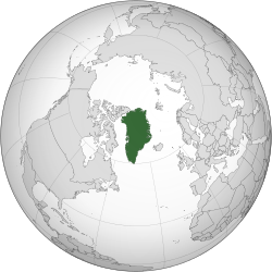
Lemah Héjo (Kalaallisut: Kalaallit Nunaat hartina "Lemah Para Kalaallit"; Basa Dénmark: Grønland)[4] nyaéta hiji nagara otonom dina Karajaan Dénmark, aya antawis Arktik jeung Samudra Atlantik, wétaneun Arsipélago Arktik Kanada. Lemah héjo mangrupa pulo nu panggedéna aréana sadunya nu sanés hiji buana.[5]
| Kalaallit Nunaat Grønland Lemah Héjo |
||||||
|---|---|---|---|---|---|---|
|
||||||
| Lagu Nunarput utoqqarsuanngoravit |
||||||
 |
||||||
| Ibu kota (jeung kota panggedéna) | Nuuk (Godthåb) | |||||
| Basa resmi | Basa Dénmark, Basa Kalaallisut | |||||
| Grup étnis | 88% Inuit (kaasup campuran Inuit-Dénmark) 12% Éropa (kalobaannana urang Dénmark) |
|||||
| Démonim | Greenlander, Greenlandic | |||||
| Pamaréntah | Démokrasi parleméntér dina hiji monarki konstitusional | |||||
| - | Raja | Frederik X | ||||
| - | Komisionér Luhur | Julie Præst Wilche | ||||
| - | Perdana Mentri | Múte Bourup Egedé | ||||
| Otonomi | dina Karajaan Dénmark | |||||
| - | Kadaulatan Norwégia[a] | 1261 | ||||
| - | Hubungan ngadeg deui | 1721 | ||||
| - | Dibéré ka Dénmark[b] | 14 Januari 1814 | ||||
| - | Status amt | 5 Juni 1953 | ||||
| - | Kakawasaan imah | 1 Méi 1979 | ||||
| - | Otonomi salajengna jeung kakawasaan sorangan | 21 Juni 2009[1] | ||||
| Aréa | ||||||
| - | Total | 2.166.086 km² (ka-12) 836.109 mil² |
||||
| - | Cai (%) | 83,1[c] | ||||
| Populasi | ||||||
| - | Perkiraan Januari 2011 | 56.615[2] | ||||
| - | Kapadetan | 0,027 /km² (ka-241) 0,069 /mil² |
||||
| GDP (PPP) | Perkiraan 2007 | |||||
| - | Total | $2,122 milyar (-) | ||||
| - | Per kapita | $37.517[d] (-) | ||||
| HDI (1998) | 0,927[3] (luhur pisan) (-) | |||||
| Mata uang | Krone Dénmark (DKK) |
|||||
| Zona wanci | GMT (UTC+0 nepi ka −4) | |||||
| TLD Internét | .gl | |||||
| Kode telepon | ++299 | |||||
| a. ^ Monarki Dénmark nepi ka Lemah Héjo dina 1380 kalawan kakawasaan Olav IV di Norwégia. b. ^ Lemah Héjo, Kapuloan Faroe, jeung Islandia baheulana resmi piboga Norwégia nepi ka 1814 sanajan 400 taun monarki Dénmark saméméhna. c. ^ Taun 2000: 410,449 km2 (158,475 sq mi) bébas és; 1,755,637 km2 (677,855 sq mi) katutup és. Kapadetan: 0,14/km2 (0,36 /mil pasagi) pikeun wewengkon bébas és. d. ^ Pakiraan 2001. |
||||||
Lemah héjo geus dieusian, sanajan teu teterusan, ku urang Inuit langkung Kanada pikeun 4500-5000 taun.[6][7] Dina abad ka-10, urang Norse midumukan bagian kidul Lemah Héjo. Dina abad ka-13, Inuit datang, sarta dina ahir abad ka-15, koloni Norse ditinggalkeun. Dina awal abad ka-18, hubungan antara Skandinavia jeung Lemah Héjo ngadeg deui sarta Dénmark nyieun kakawasaanna kana Lemah Héjo.
Tempo ogé
éditCatetan suku
édit- ↑ "Self-rule introduced in Greenland". BBC News. 2009-06-21. http://news.bbc.co.uk/2/hi/8111292.stm. Diakses pada 2010-05-04
- ↑ Statistics Greenland, Greenland in Figures, 2010
- ↑ "United Nations Island Directory". Islands.unep.ch. Diakses tanggal 2010-09-06. Archived 2009-03-28 di Wayback Machine
- ↑ Stern, Pamela (July 2004). "The Dictionary". Historical dictionary of the Inuit. Lanham, Maryland: The Scarecrow Press, Inc. p. 89. ISBN 0810850583. OCLC 54768167.
- ↑ "Joshua Calder's World Island Info". Worldislandinfo.com. Diakses tanggal 2010-09-06.
- ↑ "The history of Greenland – From dog sled to snowmobile". Greenland.com. Diakses tanggal 2011-09-10. Archived 2011-09-27 di Wayback Machine
- ↑ "Migration to Greenland - the history of Greenland". Greenland.com. Diakses tanggal 2011-09-10. Archived 2011-09-05 di Wayback Machine
Bacaan salajengna
édit- Ehrlich, Gretel, This Cold Heaven: Seven Seasons in Greenland, (Vintage, 2003)
- Kpomassie, Tete-Michel, An African in Greenland, (NYRB Classics, 2001)
Rujukan
édit- Alley, Richard B. The Two-Mile Time Machine: Ice Cores, Abrupt Climate Change, and Our Future. Princeton University Press, 2000, ISBN 0-691-00493-5.
- Bardarson, I. (ed. Jónsson, F.) "Det gamle Grønlands beskrivelse af Ívar Bárðarson (Ivar Bårdssön)", (Copenhagen, 1930).
- CIA World Factbook, 2000.
- Lund, S. 1959. The Marine Algae of éast Greenland. 1. Taxonomical Part. Meddr Gronland. 156(1), pp. 1–245.
- Lund, S. 1959. The Marine Algae of éast Greenland. 11. Géographic Distribution. Meddr Gronland. 156, pp. 1–70.
- Steffen, Konrad, N. Cullen, and R. Huff (2005). "Climate variability and trends along the western slope of the Greenland Ice Sheet during 1991–2004," Proceedings of the 85th American Meteorological Society Annual Meeting (San Diego).
- Stern, Pamela R. Historical dictionary of the Inuit. Scarecrow Press, 2004. ISBN 978-0-8108-5058-3
Tumbu kaluar
édit| Pék paluruh émbaran nu leuwih loba ngeunaan Lemah Héjo ku jalan nyungsi proyék sabaraya Wikipédia | |
|---|---|
| Définisi kamus ti Wiktionary | |
| Buku téks ti Wikibooks | |
| Cutatan ti Wikiquote | |
| Téks sumber ti Wikisource | |
| Gambar jeung média ti Commons | |
| Warta ti Wikinews | |
| Sumber pangajaran ti Wikiversity | |
Tempo ogé Lemah Héjo di Wikivoyage
- Pamaréntah
- Greenland Home Rule loka pamaréntah resmi (dina Basa Inggris)
- Éntri Greenland di CIA World Factbook
- Lemah Héjo di Open Directory Project
- Atlas Greenland Wikimedia, ngandung peta ngeunaan Greenland.
Koordinat: 72°00′N 40°00′W / 72.000°N 40.000°W
Citakan:Danish overseas empire
Citakan:West Nordic Council Citakan:Nordic Council
| Artikel ngeunaan géografi ti hiji nagara atawa wewengkon ieu mangrupa taratas, perlu disampurnakeun. Upami sadérék uninga langkung paos perkawis ieu, dihaturan kanggo ngalengkepan. |

